团队数据 | 北京大学袁文平团队更新发布中国单季稻、双季稻种植分布数据集
- :北大袁文平团队
- :2026-03-05
近日,北京大学碳中和研究院、城市与环境学院袁文平教授团队通过生态网络云平台(http://www.nesdc.org.cn/)更新发布了中国单季稻、双季稻种植分布数据集,用户可在线访问获取数据。此次更新发布了2025年10米/20米的单季稻、双季稻种植分布图,同时提供了重采样至30米分辨率的水稻种植分布图以便用户使用。
水稻是中国第二大粮食作物,在保障全球粮食安全方面发挥着极其重要的作用。然而,目前还没有覆盖全中国的高分辨率水稻种植分布图。研究团队在“基于时间权重的动态时间规划法”(Time-Weighted Dynamic Time Warping, TWDTW)的基础上,利用光学遥感数据和合成孔径雷达数据开发了新的水稻识别方法,制作生成了中国21个省份的单季稻种植分布图、南方9省份的双季稻种植分布图。相关研究成果分别以“High Resolution Distribution Dataset of Double-Season Paddy Rice in China”和“High-resolution distribution maps of single-season rice in China from 2017 to 2022”为题发表在Remote Sensing、ESSD等期刊。
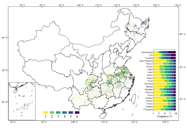
2017–2022年中国单季稻种植频率图
论文信息:
Pan, B., Zheng, Y., Shen, R., Ye, T., Zhao, W., Dong, J., Ma, H., and Yuan, W.: High Resolution Distribution Dataset of Double-Season Paddy Rice in China, Remote Sensing, 13, 4609, https://doi.org/10.3390/rs13224609, 2021.
Shen, R., Pan, B., Peng, Q., Dong, J., Chen, X., Zhang, X., Ye, T., Huang, J., and Yuan, W.: High-resolution distribution maps of single-season rice in China from 2017 to 2022, Earth Syst. Sci. Data, 15, 3203–3222, https://doi.org/10.5194/essd-15-3203-2023, 2023.
数据链接:
2017–2025年中国10米/20米分辨率水稻种植分布数据集